Friday, August 22, 2014

Mount Russell 14,088ft: "It's Not So Bad."

Mount Russell 14,088 ft: 7th Highest Peak in California 
#8 in the Summit Fever Challenge
Aug 19, 2014
By: Stefanie Notte

Oh, Mount Russell.  You got away from me once, and once was enough.  I first met you July 21, 2014 when I tried (and failed) to climb you in a day.  I made it all the way to your East Summit before I had to turn back due to a time constraint.  I shook it off, climbed three other badass mountains, and came back all the more wiser.  On August 19, 2014, you taught me a lesson:  perseverance and determination are the key to success, not in just mountain climbing, but in so many aspects of life.  Deep.

Day 1: 
I arrived at Whitney Portal at about 4pm.  I was not feeling any rush to get on trail since today's adventure was hastily planned last night. I was staying with some friends in Bishop, CA, and we were talking about my misfortune with Russell a month earlier. They wanted to join me on my next attempt at this mountain, so naturally I said, "lets do it tomorrow!"  And, as people of the Sierra are, they were so down!  

As I prepped for this upcoming trek, I took everything out of my car, as I always do, and packed my backpack one thing at a time, so I can see and touch everything I bring (I do this in lieu of having a tangible check list).  My one friend went to the General Store and grabbed me a Sierra Nevada Torpedo IPA, which was a delicious, yet unnecessary treat.  It took me FOREVER to pack, as I was pleasantly distracted by a nice man whom ended up purchasing my MSR Ceramic Water Filter from me.  Good riddance!  

The plan: Day 1: camp at Upper Boy Scout Lake, Day 2: summit Russell and hike out.  My approach was the same as last time: the East Ridge, my friends: Fishhook Arête.  

This was the best of both worlds: I got my solo ascent which I very much needed with the benefit of having company for every other part of this trek.  We finally hit the trail at 6:10pm (8300 ft).  We started out at the back of the parking lot, about 50 yards or so passed the General Store and up to the right.  This trail connects with the Whitney Portal Trail about 100 feet after the split to take the North Fork of Lone Pine Creek Trail.  Meaning, once you get to this intersection, go right, cross the stream, and take a left up the North Fork trail.  Got it?  It shaves off some extra distance if compared to starting at the beginning of the WP Trail.  

The crew

The sun was setting around 7:45pm and we held out as long as possible before turning on the head lamps, about an hour later.  We got to camp (Upper Boy Scout Lake) at 9:07pm (~11,400 ft).  We were camping sans tent, so we set up our beds all lined up in the row, girls in the middle, boys on the outside.  This style of camping, known as cow[girl] camping, is the best way to fall asleep-- directly under all the sparkling stars in the sky.  It did get pretty chili that night, probably down to the low 30s, upper 20s.  Guess who was stoked she had her sleeping bag liner?  

sunset from the North Fork Trail

Day 2:
I naturally woke up around 4am, with about five hours of solid sleep and zero desire to emerge from my cocoon.  I went over my last Russell attempt a hundred times in my head until I heard Megs call my name.  That girl was lucky if she got a full hour of sleep. The sun came up around 5:30am and we all had our alarms set at 6.  I was the last one out of my bag, it was a bit windy and at some point this summer, I lost all discipline to get my ass on trail on time.  This is what got me with my last attempt at Russell, I overslept by three hours.  THREE HOURS!  Who does that? You would think I would have learned my lesson by now.  Brandon, Megan, and Cristian left camp at 6:30am as I was still filtering water for my much needed HOT coffee and oatmeal breakfast.  Lagging.  I still got on trail at the base of the scree gully by 7:10am, and this is where it all began.  


It was climbing this section where I was going through my mental battles with my last attempt. One month ago I referred to this section as “the shitty gully,” and by doing so I associated negativity with it.  HIKING IS MORE OF A MENTAL CHALLENGE THAN A PHYSICAL ONE, which is just another realization I came to sometime this summer.  I faced this wall of scree with a whole new attitude; I told myself that this is just part of climbing huge mountains, especially the California 14ers.  If it was a paved road (Whitney Portal) then everyone would do it.  Once I conquered the mental aspect of this section, it wasn’t so bad.  In fact, I charged it 30 minutes faster than the last time, getting to the top by 9:01am. It was on this section that I realized I left my SPOT Gen3 sitting back at camp; it didn’t make the transfer into the smaller day pack. Oops, it's almost a guarantee I'll forget one important item on every trek (about that check list...). 
  
Mount Russell from the crest of the Scree Gully


The next section of the trip is a sandy walk to the Russell-Carillon Pass, and every step of the way you have the most incredible view of the north face on Mount Whitney, with all her needles by her side.  Gorgeous.  I clearly am having a completely different experience than last time. I’m seeing everything through a brand new lens; it’s about the experience, not the expedition. 

Mount Whitney 

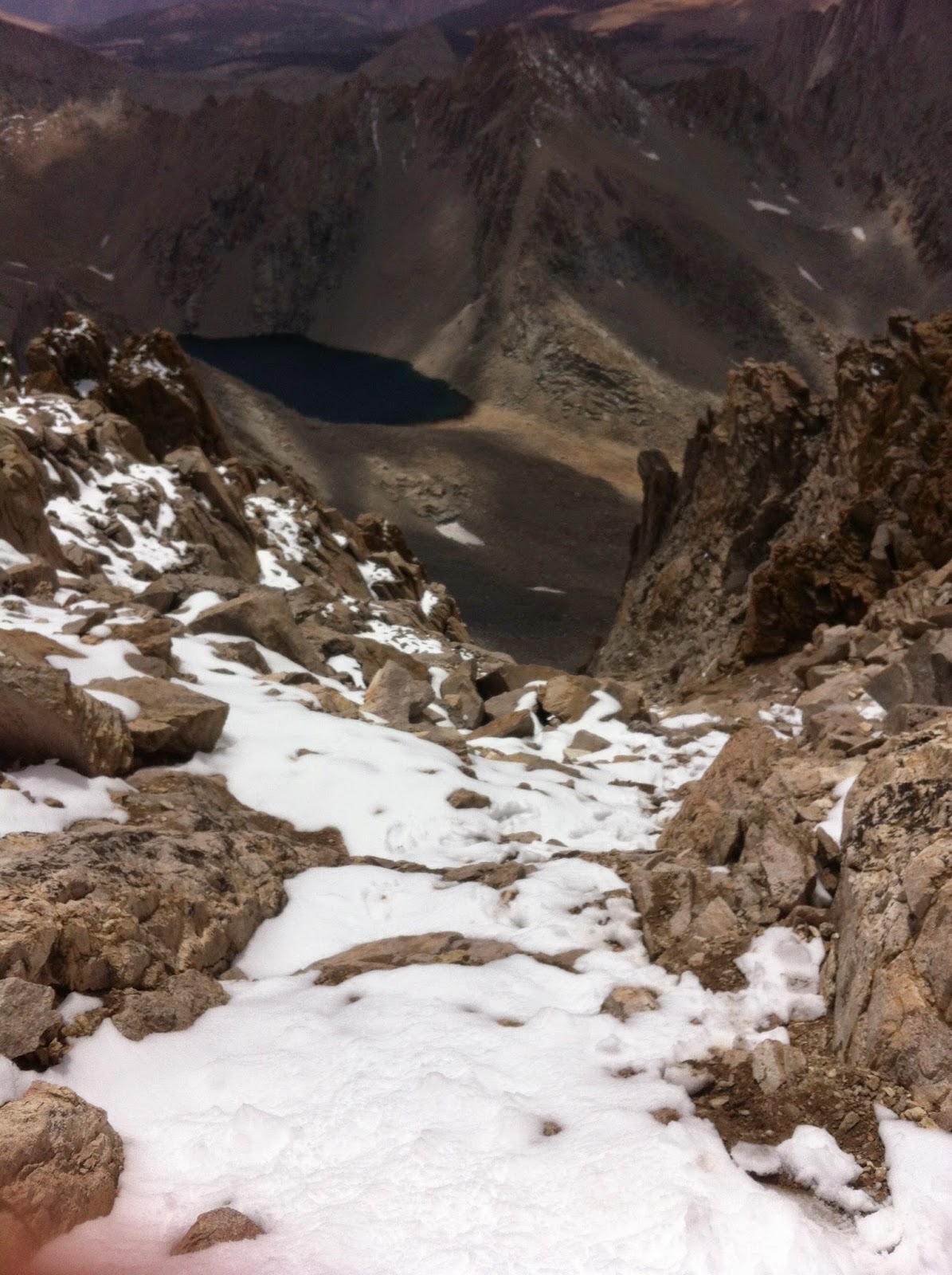
I arrived at the Carillion Pass 34 minutes later, leaving my trekking poles just off trail, propped on a rock marking their location with a large X in the sand to relocate them.  From here you can see one of the highest elevation lakes in California, Lake Tulainyo at 12,802 ft.  It looked pristine (note: this may be the highest lake in CA, but when trying to research this fact, it got messy).  The West Summit of Russell also came into view, so close yet so far.  This is where the fun begins: a class III rock scramble past the East Summit, via the ridge to the West Summit, the highest point of Russell at 14,088 ft. I took a brief snack break before this section and enjoyed a red Baby Bell and a granny smith apple, possibly the best backpacking snack combination of all time.  


Lake Tulainyo
At 10:30am I reached the East Summit, and in doing so, I have passed my previous turn-around spot!  From here on out, I am on new terrain.  I shed a tear, maybe two, I could hardly contain myself as I hiked with the sun beaming down on my face, enjoying the perfect High Sierra day.  It is worth noting, this section is HIGHLY EXPOSED, reliable hand holds become essential as well as dependable shoes.  There is a stretch between the two summits where you are walking the ridge with nothing but a sheer drop off on either side. So cool.  I think my Tyndall therapy last week was all I needed to quickly get into the rock climbing zone, one move, and then the next, slow, cautious.  It’s quite remarkable how little regard I have for heights since my mother is deathly afraid of them.  If you have even the slightest reservation of hiking in highly exposed terrain, the east ridge (and Russell for that matter) is not for you.  


North side of the East Ridge
Exposed ridge line  

At 11:38am, the most incredible thing happened, I reached the West Summit of RUSSELL!  Mount Russell, the 7th highest mountain in California brought me to tears yet again.  I have no idea why this keeps happening here, but it sure is the only mountain that has ever evoked this kind of emotion from me, and now it has happened twice!  The first time was out of pure disappointment, and this time, well, out of gratitude.  I have been humbled, put in my place, and learned many valuable lessons along the way.  I needed a little more experience on this type of terrain before charging it, and I wasn’t about to admit that 29 days ago.  This mountain has brought the best and the worst out of me, and for that, Russell has made it to the top of my favorites list.  

Me and the register, Whitney in the background 

I bet Israel was a crazy bastard 

I was here (Whitney over there) 

Lake Tulainyo and the East Summit of Russell


Megan, Cristian, and Brandon joined me at the summit via the Fishhook Arête route at 3:16pm.  I stayed on top of this mountain for over three hours before my friends joined me, taking it all in.  I was on top of Russell for almost 4 1/2 hours total, smashing my last record of chillin' on a peak by 3 1/2 hours.  The previous record was obtained last January 3rd (2014) when I soloed up Half Dome in Yosemite and spent an hour at the top, without another soul in sight.  

Way to go, Team!
The crew on the summit

At 4:01pm we all descended together.  Ugh, down climbing.  It was nice to have people around for this part because the descent is often where mistakes happen, not to mention slogging down just isn't as fun as the ascent.  In this case, I’m pleased to say nothing happened and it went quite smoothly.  I found my trekking poles at the Pass (X marks the spot!) and we marched down to camp arriving at 6:10pm.  We had a quick little snack before packing our big packs, and still had a 6+ mile trek to the cars from here.  At 6:45pm we were on our way down the North Fork of Lone Pine Creek Trail, following the cairns down the talus infested, rock slabby trail to Lower Boy Scout Lake, which we arrived 35 minutes later.  We continued through the Ebersbacher Ledges, passed the water fall, and arrived at the WP Trail junction just after dark.  We went up trail (right) for a short walk, crossing the creek and took the left onto the little unnamed trail that will lead us to the back to where we started, at the back of the parking lot down at Whitney Portal. 


Megs and I on the descent
photo credit: Brandon Commanda

We completed our mission at 8:39pm, and finished off the night at The Grill located down in Lone Pine, since the General Store at WP was closing right as we were walking up to it.  My Stone IPA, in a frosty pint, paired oh so nicely with my buffalo chicken sandwich (unfortunately, the fries weren’t all that good, they were more soggy-potatoey than crunchy, and crunchy is my favorite).  However, this restaurant saved the day by feeding this hungry crew, gearing us up for our hour drive north to Bishop.  

So, what’s next you say?  Well, I’ve saved some of the best for last: The Palisades and Split Mountain.  Shit just got real.  Split, North Pal, Mount Sill, and Middle Palisade are all up on the list, with Thunderbolt, Starlight, and Polemonium Peaks as well.  The last three are technically considered subsidiary peaks off of North Palisade and not “real 14ers” although I’m pretty sure Thunderbolt may have just made the jump to the elite list.  Either way, they count in my eyes.  There is a strange gray area in the land of the California Fourteeners; a mountain is measured on it’s prominence, if it’s prominence is less than 300 feet from the mountain it’s next to, then it isn’t considered a true mountain or peak.  Take Keeler Needle for example, it’s elevation is 14,260 ft. Since it is next to Mount Whitney which is 14,508 feet tall, it’s prominence is only 248 feet, downgrading it to a subsidiary peak.  Make sense? 

But, before I head to the Palisades, I’ve got an awesome adventure next on the list, one that has been on my mind for a few years now: the one, the only, John Muir Trail.  I start this quest in less than a week, August 28th to be exact and I can’t even explain the whirlwind of thoughts going through my mind!   But, one thing is for certain, it’s about the experience, not the expedition (although I may snag Split Mountain from the trail!).... Happy Isles to Whitney Portal, 220.8 miles, I am STOKED!  

Thank you, Mount Russell, for this experience. I am walking away from this one as a better mountaineer.  This experience was priceless!
Mount Russell
Photo credit: Brandon Commanda

11/16/2014
Update: I have finally come to terms with the fact that I will not be completing the Summit Fever Challenge by the end of 2014.  I did, however, complete the JMT back in September, and it was just incredible... there are no other words to describe it.  Wait, yes there are, but John Muir said them himself, and did so in such an eloquent manor that I'll leave it at that.  I will say we only had one day of disastrously, terrible weather (in 16 days), and that just so happened to be the day I was supposed to summit Split Mountain.  I'm learning to take these challenges in stride, and one thing is for sure, these mountains aren't going anywhere!!  I'll be back soon, until then...

Arrivederci.


Monday, August 18, 2014

(PART II) Mounts Williamson and Tyndall: A Two Part Adventure

Mount Williamson #6: 14,380 ft; 2nd highest peak in California
Mount Tyndall #7: 14,026 ft; 10th highest peak in California
August 9-10, 2014

By: Stefanie Notte

PART II

Day 3: Sunday
The New Plan: Waking up early and hit the trail 5am. Summit Tyndall and head back to the car (These plans never seem to work). 

I woke up at 5:58am, clearly I slept in. You know those moments when you lay in bed talking yourself out of your first plan just so you don’t have to face the music, all the while staying put in your comfortable nest?  Let’s just say, I was no longer in any hurry to get the day started.  I justified it a hundred ways.  I was tired.  The moment I leave camp I am on a solo hike, and up till this point, I really enjoyed being part of a bad ass team of women.  I wasn’t ready to let that go. I stayed in bed scanning over my body; my feet were the most sore, followed in descending order by my calves, hamstrings, glutes, quads, abs, shoulders.  I laid there in and out of sleep until the inevitable happened, time to go pee.

I had breakfast with the girls, they were getting ready to head back today since they had already summited Tyndall last summer.  I was getting mentally prepared for another hike up the Pass, which in all reality, wasn’t that bad from Anvil Camp.  The one element I’d be facing this time was the heat from the late morning sun.  That is the best part of hiking in the dark, it’s cool enough so you can just keep pressing on while taking less cool down breaks. Anyway, it was during breakfast when I determined that I was going to camp one more night.  Why not?  I like the idea of having a base camp, and I was feeling pretty attached to it.  And, I just shaved off 9+ miles of hiking that day with this epic decision!  But you know what sucks?  My damn Merrells were still soggy.  Fuck those boots.  
Tyndall again from Shepherd Pass

At 9:45am, I was back on trail heading west.  At 10:46am I was at the base of Shepherd Pass and 28 minutes later I was at the crest.  Still making pretty good time.  At 12:11pm I reached the class 2 rock scramble to the North Rib of Tyndall.  This approach is a class 3, and I had a huge realization here.  I AM A SLOW CLASS 3 CLIMBER.  Well, slow to moderate.  I don’t know why that is.  The elevation? The lack of experience?  Being overly cautious?  All the above I suppose.  But, this is good to know.  It got the best of me when I attempted Russell, I followed the timeline in my book: Climbing the California Fourteeners, and shit, I can’t compete.  Anyway, I was in my element, taking my time, enjoying this full body workout.  Finally, I can take some of the pressure off of my legs!  And I have to say, this route was AWESOME!  The only hiccup was when I had to reroute a few times to avoid all the newly fallen snow.  There was one thing I was unwilling to compromise, and that was TRACTION.  Oh, sweet traction!  Hiking in the wet BS yesterday made me realize that I wasn’t going to give in on this one.  At least the bottom of my boots were going to stay dry.  TRACTION!  What a glorious thing.
Almost there! (Williamson to the left)

correction: summitfever2014.blogspot.com , dummy.  

Russell, middle left; Whitney middle right 
High Sierra to the north west


Mount Williamson, she's awesome 
At 2:38 pm, I had summited this beast known as Mount Tyndall!  YESSS!  My PB&J was complete, and I can now call this trip a total success!  Williamson and Tyndall, check and CHECK!  It was a beautiful summit.  Great views of Williamson, Milestone, Whitney, Russell, Langley, and beyond!  The sky was so blue.  What a difference a day makes.  The sun was beaming down on me, and yes, this is when I thought it was a good idea to have that shot of Bourbon.  SO GOOD!  I chilled here for about 45 minutes soaking in that feeling one gets when they feel as if they’ve made it to the top of the world.  And just to note, this register was an easy find.  I also climbed up the exposed rock on top to touch the top.  Now, it counts.  Liquid courage. Well, I have to say that I felt a little woozy on the way down, my judgement seemed to have been altered in a less than positive way.  Oops.  I cruxed for a moment on the descent, rerouting four times before I navigated a possible route.  This kept happening.  I think I was mentally exhausted from this trip.  I was physically tired as well, but not to a point that was compromising.  And, I still felt a slight buzz from that single shot.  Cheap date.  
A questionable but delicious decision (Williamson in the background)


View of the eastern side of the North Rib. Don't slip!


I took a long and arduous route down, zig zagging the rib, and boy, my quads were on fire!  I got back to the Pass at 6:38 pm.  I was out of water.  I was actually out of water for a while but I was not going to stop to filter until I got below the Pass.  It was a mental thing, I just wanted to be closer to camp and finished hiking for the day.  And besides, the lake I stopped at had marmot poop all over.  Damn those scavengers.  I’m going to filter at the creek on my way to camp.  And so I did, somewhere near Pothole.  And you wanna know what else?  “Something is seriously wrong with my MSR ceramic filter, it took nearly 30 minutes to filter 3 liters. Piece of shit. Good thing I'm upgrading to the Sawyer Mini, too bad I left it in the car, too.”  This filter has been the bane of my backpacking existence for quite some time now.  I was always underwhelmed by it’s performance. It takes too long to filter and too much effort.  Seriously, the worst purchase of 2012.   The best? Oh, my green Jetboil Flash with Coffee Press attachment, of course.  

On my way to camp I saw a man with one hiking boot and one Chaco on.  Strange, right?  Poor guy lost a Chaco when crossing the river by my camp.  Actually, this conversation started because he asked me if that was my camp by the river.  I looked at him in a reserved manor, asking him why before admitting to it.  He wasn’t weird or anything, this was just an instinctual reaction.  Then he went into the lost Chaco bit and asked if I could keep an eye out for it.  He was camped close to Pothole, and didn’t have the energy to go back down the hill on a sandal hunt.  Well, let me tell you, he asked the right person.  I was on a mission to play the hero for a minute.  And to no surprise, I found the Chaco about 100 feet up trail from my camp!  YAY!   I took some paracord and tied it to a tree by my camp so it would be an easy find on his way out.  

I got to camp at dusk, partially because it took me so damn long to filter water.  I was beat.  I chugged some water, cleaned up, and crawled back into my down Marmot Angelfire with the liner.  This is the best combo.  I love having a liner for my bag.  It’s like a sheet under a comforter, it’s now a necessity.  And I was out.

Some time during the night, I woke up to an illuminated sky.  The fucking super moon.  Great.  Now we have different names for full moons.  This is getting a little ridiculous. Anyway, the super moon was super bright and keeping me awake for longer than I cared for.  Super.  I eventually fell back asleep.  The next time I woke it was to a bright light again, but this time it was a giant lightning bolt!  This was quickly followed by crackling thunder and a fucking monsoon.  I wish I had a camera that could have done a time lapse or something during this night, because it was full of drama!  Picture this: sleepy me in my green Angelfire in a crouched position with my pack under my ass and my feet together.  I wrapped my arms around my legs and sat there with my head down and eyes closed, in my fuck-off-lightning position.  This storm was right over head, and stayed there for a while.  I was actually afraid to touch my phone to see what time it was because I didn’t want to be associated with any metal, even if it was just my shitty iPhone 4 with a smashed screen.  My Kelty Mesa 2, at a whopping 4 lbs and 11 ounces, was impressive in this rain, not a single drop of water diffused inside.  Not one!  Yes, this was worth the weight.  Go fuck yourself, ultra lighters! Just kidding.  Not really.  I’m still waiting for the day where I can justify spending $500 on a tent, until then, I’ll just appreciate the work out.


Day 4: Monday


Bored, taking pics of myself.  Nice hair.  
Another plan -> wake up early, break down camp early, and get on trail EARLY!  Sounds good, right?  That didn’t happen either.  Early was just not working for me this trip.  This time, it was because of the rain.  It was a stormy morning, thunder, lightning, the whole bit.  Not letting up.  8am came and went.  That was my goal time.  Shit.  None of this was too big of a deal, except that I was planning on being in Sacramento later that day to surprise a friend.  9 o’clock came and went.  Ugh.  I’m now getting bored.  My bag is packed, my boots are semi dry in the vestibule, but my insoles are sitting out in the elements where I left them to dry overnight. Lightbulb!  I went into my first aid kit and pulled out the foot warmers I purchased after the White Mountain trip.  These ones go the entire length of my boot, so there you have it, warm and toasty insoles! I am literally sitting, waiting, wishing for the rain to stop.  Thanks for that Jack Johnson.  9:45am, there it is!  The break in the rain I’ve been waiting for.  Quick!  Move it!  I broke down my soaking wet tent in record speed, attached it to my bag, and fled the scene by 9:57am.  


To the east

To the west

Here we go, a quick nine point five miles to the car.  Racing the clouds.  I was winning for about an hour, and then had to walk up that initial pass.  It slowed me down, but barely. Day 4 of trekking and my trail legs were in full effect!  I reached the top of the pass by 11:49am, ten minutes after the rain caught up with me.  I looked east, and it was a sunshiny day in the town of Independence.  I looked west, and it was a dark angry day in the High Sierra.  I kept moving, no breaks.  Moments later, the dark clouds won, and from that moment on, I was hiking out in the thunderstorm.  Every step of the way.  I got to Symmes Creek at 1:10pm, and knew I was getting close to the finish line.  At 1:24pm, I reached the trail head!  Parking lot full.  Still pouring rain.  I had to walk the additional 1.4 miles to my car from here, and I did note that, if in fact my car made it to the trail head, there was no way it would be coming out of there!  The road consisted of two mini rivers and was washed out more than ever before.  Okay, everything happens for a reason.... the MINIsituation was a life saver!  The last section of hiking went by in a blur, but the excitement of seeing my car was in full effect as it always is after a trip!  


The stormy mountains

At this moment, at 2:03pm on Monday, day 4, I took off my Merrell Moab Ventilators for the last time.  Bittersweet.  They looked like shit.  But, they certainly brought me to some amazing places.  An ode to my Merrells:

Dear Merrells, you were a great boot.  I acquired you in 2012 right before my first epic Mt. Whitney trip.  I know I didn’t break you in sufficiently, but I do recall that gigantic blister you created on the inside of my left heel.  I secretly hated you, for each step I had to take for the rest of that trip (8 miles to go).  And then, I fell back in love with you for each trip thereafter.  You brought me to the top of Kilimanjaro (a nineteener!), and for that, I will forever be thankful. It really wasn’t until the White Mountain trip earlier this year that I started to despise you again.  And from there, I knew you were in your golden years.  Now, you reside somewhere in a dumpster in Sacramento, not the best burial, but appropriate none the less.”


Dear Williamson and Tyndall, thank you for the challenges you provided me on this epic trip.  Williamson, you are a huge bitch!  And Tyndall, you are a tricky lil’ mountain as well.  I respect you both, and now, to the next endeavor.  Yep, Russell.  I’m coming back for you!

(PART I) Mounts Williamson and Tyndall: A Two Part Adventure

Mount Williamson #6: 14,380 ft; 2nd highest peak in California
Mount Tyndall #7: 14,026 ft; 10th highest peak in California
August 9-10, 2014
By: Stefanie Notte

Ah, Williamson and Tyndall.  They go together like peanut butter and jelly.  Rarely do you get one without the other... but they are both fantastic (and could get messy?) individually.  This trip officially started on Friday, 8/8/14 at 12:46am and ended on Monday 8/11/14 at 2:03 pm, and let me tell you, there was a whole lot in between to keep one on their toes!  This weekend rounded out numbers 6 and 7 for the Summit Fever Challenge 2014, getting me two steps closer to finishing one of the most epic adventures of all time.  

Like most stories, the more crazy shit that happens, the more exciting it is to read.  However, that was not my intention when the MINI-fiasco occurred in the middle of the night, 8 hours before the planned start of the trip.
Happy MINI


PART I

It all started when I was car camping at the corral just before the Shepherd Pass trail sign. I slowly and methodically packed my bag for the next three days and eventually drifted off to sleep. So nice and peaceful, I was going to meet the girls here and go up to the trail head together. Then, at 12:24 am, I was awaken by a car driving passed me towards the trail head... a car with low clearance! I was a bit confused at first since my book: Climbing the California Fourteeners states clearly that driving past the corral where I was camped could not be done without a car with high clearance, and the ranger at the permit office confirmed this as well.  Since I had such good cell phone reception, I pulled up the summitpost.com site on Williamson and it contrarily stated that low clearance cars could make it all the way to the trail head. That was that. I packed up, jumped in the Mighty Mini and off I went at a staggering 5 mph up the road... Until I got to a split in the road that was totally washed out by the recent down pours making this stretch impassable with the mini. Damn. Okay, good run, time to head back... That is... Until I got this car stuck on the side of the road trying to turn it around. So fucked. 

The front bumper was buried in the shitty dirt road and the front tires were spinning... Deeper and deeper, while the car was angled ass up/ nose down, perpendicular to the road. Now, at this point I am still optimistic. I grab my poo shovel from my packed bag and go to town digging out the mini. 2 minutes into this task and I have successfully shredded my knuckles on both hands. Hmmm. As I was tearing through my now unpacked bag for some medical tape to bandage my bloodied hands, I noticed my ice axe. Score! I spent the following 2 hours in the middle of the night trying to dig a trench under the bumper by jacking up my car on  one side, then the other, eroding away the dirt road.


This was two days later, just imagine the feeling every time you reach into your pack.


 The moon had finally disappeared and darkness fell around me. The batteries in my headlamp died while I was hard at work mining my mini but I still wasn't giving up. I replaced the three AAAs without skipping a beat and started sticking rocks under the elevated front tires. I'm feeling confident.  I was both eager and nervous to test out my progress.  I get back in the driver’s seat when I tried backing up and out of the now (wo)man made ditch. Nothing.  No, worse.  The rocks spit out from under the tires and the MINI went even deeper into the soft road, making my awesome trench disappear in just seconds. Well, fuck. 

Oh wait, a car is coming! Blue Subaru.  It's now just after 3am and this guy was on his way up to day trip Mt Tyndall; he didn't have the time to help me.  Yes, that’s right, Blue Subaru passed by me and my MINIsituation because he had quite possibly a mild case of summit fever.  Well that's okay, summiting sometimes blinds the nicest of people, and you better believe I was not going to act as if I needed help, no matter how fucked I was.  He drove around my trench, a little displeased on how close he had to squeeze pass the bush that could potentially scratch the paint on his precious functional car, and went on his way. Defeat. I finally called a tow guy (in Lone Pine) around 3:30am and his best answer for me was, "call back at 8am". Emergency tow my ass. At this point I threw in the towel and tried to get some sleep, I was a new kind of exhausted. 

Sad MINI


The sun came up way too soon and there I was, now in day light, in the --so I wasn’t dreaming after all-- MINIsituation. Okay, back to jacking up the car and trying the rock thing again.  Finally, luck swayed back in my direction.  It was 8:02am and another Subaru was approaching my car.  This time it was red.  But best of all, my two hiking partners, Jill and Leslie, were in that car and were hell bent on getting me out of there!  Jill grabbed the brand new unused Subaru jack from her car and Leslie grabbed the full sized shovel.  Together this team of women worked diligently to bust that MINI free.  And you know what? IT FUCKING WORKED!  Is anyone surprised? Hell no.  And now the trek can finally begin.

The Subaru Jack, an amazing invention

Progress!
SUCCESS!


The Plan: 
Day 1 -> Anvil Camp, about 8.5 miles in and 4000 feet elevation gain
Day 2 -> Summit Mount Williamson from the western approach as a group, and I was to solo summit Tyndall via the North Rib
Day 3 -> Bag Tyndall if I didn’t the day before, and exit by dark

Day 1: Friday
The three of us hit the trail at 9:50 am from the Shepherd Pass trail head at 6300 feet. I forgot my trekking poles in the MINI.  My car was parked down by the corral again and it was too far to go back.  Dang, what else did I forget?  By 10:28 am we reached the fourth and last water crossing on Symmes Creek before switchbacking up to the first pass.  We filtered water here.  The trail was well defined with soft terrain and was pretty nice if you ask me.  We reached the top of the pass at 12:40 pm, and boy was I feeling the elevation at this point.  We continued down the other side until we got to a shady spot with a stream and decided to take our lunch break here, at 1:10 pm.  It wasn’t until just before 4pm when we reached the section of the trail that was washed out by an avalanche in 2007.  Tricky icky icky!  Steep down, steep up.  We managed just fine.  This is also where we had our first sighting of real Trail Ninjas.  Where did these two guys come from?  We had no idea. Hmmm. 
Washed out trail, approx. 15 foot walls

Moments later, a man was coming towards us, I recognized him immediately.  Blue Subaru.  No, I wasn’t bitter... We chatted a bit, he got his summit, and then I volunteered the info that there was no longer a MINI blocking the road on his way out.  HA!  To much of his surprise, I told him that we got that car out with minimal trouble, yes, the three of us LADIES.  Okay, maybe a little bitter.  But, either way, it was a win win. 4:14pm and we had arrived to camp.

The Trail Ninjas were sitting on a log checking their map.  I didn’t realize ninjas used those.  We chatted with Steve and Pryor for a few minutes longer, until something remarkable happened.  Steve asked me confidently, “are you Stefanie?” Holy shit.  This ninja had read my blogs before, and KNEW WHO I WAS!  So cool.  I have to say, this moment was a true highlight for me.  Off they went to camp up at Shepherd Pass, and here we were at home sweet home. At 7:54 pm I was tucked into my super cozy camp bed.  I laid down for nearly 30 seconds before completely passing out, dead to the world. 

Day 2: Saturday

“3:15am: first alarm, NO!
3:33 am: second alarm: not yet but better
3:43am: third alarm and I'm up, time for some coffee.”

We fueled up with some delicious coffee and I had some super oatmeal: Oats, chia seeds, almonds, dried berries, BANANA POWDER (yes, I created this epic electrolyte filled sugar substitute), cinnamon and a dash of salt.  4:49 am and we were on trail, next stop Shepherd Pass (12,000 ft). 
Mount Tyndall from Shepherd Pass

We crested the Pass at 6:13 am.  The sun was rising and casted a beautiful morning glow on Mount Tyndall.  It was breathtaking. 45 minutes later we reached the northern edge of the Williamson Bowl.  Shit just got real.  Snow capped Williamson dominated the south eastern sky, whereas Tyndall stood closer to us, directly to the west, but 300 feet lower than it’s behemoth neighbor.  I felt small.  I’ve learned by now that although this mountain appeared close, it certainly was not.  Now for the much anticipated High Sierra cross country expedition across the great Williamson Bowl. We descended south into the bowl, following cairns to the lake closest to Tyndall.  We hugged the eastern perimeter of these two lakes (continuing onto the lake directly south of the other) and finally and accurately located the “black stain” marker on Williamson.  At 10:00 am “...we ascended the class 2 western approach, the route became more clear and the black stain was the landmark after all.  There was water running down it, most likely from the snow melt from last week's storm. The chute is directly above that section and the route with the chimney is on the left side, NOT the right.” What is that over there?  OH!  The Ninjas.  Where do they keep coming from?  They are about 45 minutes ahead of us and moving all stealth-mode and fast-like. 

The chute to take, GO LEFT!

Crux. The Merriam Webster Dictionary defines this word as: “a puzzling or difficult problem, an unsolved question; an essential point requiring resolution or resolving an outcome”.  I define it as the Williamson Chute.  Our route was covered in hard snow, unstable rocks of all sizes, and was of a humbling steepness that demanded respect.  About half way through this beast, the giant rock I was standing on dislodged, and I watched with bewilderment as it rumbled and tumbled its way down the chute. It took an eternity for it to meet its final resting place, and that’s when every hair on my body stood up in the erie silence. Fuck.  I just want to get to that chimney. At some point around this time, Leslie handed me one of her trekking poles.  It was an essential piece of equipment that I was missing all along.  Finally, some stability.  Keep on truckin.  It was also at this point that I officially gave up on trying for Tyndall later that day.  Focus.  This chute demanded undivided attention.  


Roughly an hour later we got to the chimney.  YESSSSSSSS!  Now, looking back in hind sight, this was another highlight of my trip.  Sure, it may not seem tricky to the rock climbing population, but since I am technically not a rock climber, I was soooo stoked to get through this part!  It really was a challenge, but with the guidance from my experienced team, it was a piece of cake! Oh, and this was also where we met up with the Ninjas again.  Don’t ask me, this was an ongoing thing.

Photo cred: Jill Wilson 


Moments later, at 12:26pm, we reached the snowy summit of the 2nd highest peak in California!  Woohoo!  Mount Williamson has now been checked off the list, #6 for me and #7 for Jill and Leslie (in the conquest of the CA 14ers).  The three of us shared our summit experience with Steve and Pryor, but none of us could find the damn register!  It was buried under the snow, and there was no way we were going to find it.  Whatever, it still counts.  

Snowy summit of Mount Williamson!


And now, the descent.  Down the chimney, down the chute, down down down.  At 3:27pm we reached the Bowl, but still had to face the class 2 rock scramble over to the other side.  As we were doing so, dark clouds rolled in, taking over our blue skies.  My legs were getting tired.  And my feet, well, I was rocking the swamp foot.  They were saturated and there was nothing I could do. Go go go. My decision to skip Tyndall started to feel like a good idea after all.

Down the chute, it all makes sense now, huh?

At 4:53pm we reached the northern end of the Bowl once again.  As we were ascending, it started to hail.  No big deal, right?  And then, it came down harder and faster.  The hail was growing in size, about 1/2 a centimeter, and then.... the lightning and thunder.  We were perched in the Williamson Bowl Amphitheater with front row seats to one of those crazy High Sierra storms.  First the flash of lightning, then the crackling thunder, and then the booming echoes from the thunder bouncing off the giant mountains all around the Bowl.  It really was incredible.  We were crouched down with our feet together trying our best not to get struck by lightning.  

Just one short week before this trip, I was standing on top of Mount Tallac (9738 ft) in Lake Tahoe during a thunderstorm and my hair was sticking straight up.  Later that day I did some research about lightning strike prevention and HOLY SHIT, I was so close to getting my ass zapped when I was on that mountain!  Too close.  I now have a healthy fear of these electrical bolts.  
Tallac Thunderstorm: Yep, this really happened 

After about 30 minutes, the seconds between lightning and thunder increased and we were on our way.  That is, until a few minutes later when the storm decided to circle back over us... and back to the defensive position we went, this time for only about 20 minutes.  Now I’m freezing.  This is when I could have used my mid layer, beanie, and gloves... all things that were in the original packed bag that ended up left behind in the MINI.  Awesome.  Remember my swamp feet?  Yeah, this didn’t help that, either.  But one thing is for sure, I will not act casual around lightning again.  Thank god I wasn’t on Tyndall for this shit!  Uh oh, I hope the Ninjas didn’t get stuck in it up there.


Milestone Mountain (in the middle)
Oh, HAIL no! 
Jill and Leslie en route to the Pass


We reached the top of Shepherd Pass at 6:32 pm.  The ground was now covered in a blanket of white hail/snow mixture.  It was pretty. But more importantly, we got back to our base camp less than an hour later.  Camp held up well.  My castle was completely dry, it looks like it benefited from that waterproofing it endured shortly after the episode in Mount Rainier two months prior, where I had a moat around my Thermarest Island for roughly 36 hours.  Jill, Leslie, and I gathered under these awesome LED lights at camp and prepared our dinner: I had mashed potatoes with the Mountain House fire roasted veggies. Delish.  Hot and filling.  And hot.  Funny how hot and filling can make someone so sleepy, and with the addition of a 14 hour hike, sleep was the only thing I desired more than that shot of Jim Beam.  Looks like I’ll be taking it to the top of Tyndall tomorrow.  Oh yes, I still haven’t forgotten about the jelly to my peanut butter.  Looks like I’m headed back up Shepherd Pass tomorrow.  Did I bring enough food for an extra day of hiking? No.  I really thought I could have done both peaks in one day.  Fat chance!  Once again, these two ladies come to the rescue.  They resupplied me to get through another full day of hiking.  What a team, I tell ya.  Buenas noches.  

Dinner at Anvil Camp